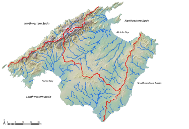
map_mallorca_basins.png

Größe dieser Vorschau: 800 × 547 pixels. Andere Auflösungen: 150 × 102 pixels 375 × 256 pixels 750 × 513 pixels 1125 × 770 pixels 1500 × 1027 pixels
thesis:map_mallorca_basins.png ( 1500 × 1027 pixels )
Information
| Datum: | 2021/01/27 14:37 |
|---|---|
| Dateiname: | map_mallorca_basins.png |
| Format: | PNG |
| Größe: | 1MB |
| Breite: | 1500 |
| Höhe: | 1027 |
Verwendung von
Diese Liste ist möglicherweise nicht vollständig. Versteckte und durch ACL gesperrte Seiten werden nicht angezeigt.
- thesis/floods_mallorca.txt
- Zuletzt geändert: 2021/12/08 14:43
- von m.brunner